How the expedition came to be:
The idea for this trip was originally Sarah's. Shortly after we came back from a 5 day kayak trip on the South island of New Zealand, Sarah suggested that we one day paddle down the Mississippi River. Sarah’s enthusiasm for the trip has since been tempered by the realization that the Mississippi will require a great deal of toiling under the sun and battling mosquitoes, but I have remained enamored with the idea ever since she proposed it. We put the river on the backburner for a few years, but this year, thanks in part to Fund for Teachers, things worked out for the trip to come together.
When I came across the Fund for Teachers Summer Fellowship Program I began to think about the river once again. Fund for Teachers is an organization that supports teachers in a variety of ways. One of their most innovative programs is the Summer Fellows program which awards grants that allow individual teachers and small teams of teachers to design fellowship experiences tailor made to improve their own teaching practice. This year alone Fund for Teachers in partnership with the Chicago Foundation for Education funded 31 proposals that will enable 49 Chicago Public School teachers to travel to 22 countries and 6 continents as they pursue their lifelong professional dreams. This year’s fellows will pursue activities as diverse as studying penguins off the coast of South Africa, attending a puppetry workshop in Italy and documenting folk festivals in Peru. Click the link on the top right of the page if you would like to learn more about Fund for Teachers.
My fellowship will allow me to conduct scientific research on nutrient pollution and microhabitats in the Lower Mississippi River as I paddle a sea kayak more than 1,000 miles from St. Louis to New Orleans. During the trip Sarah, Pat and I will be traveling in Feathercraft folding kayaks and camping nearly every night on sandbars, islands and the banks as we make our way down river collecting chemical and habitat data. Using this field experience I will develop a river ecology unit for my biology students.
What we hope to learn:
The chemical data that we will be collecting will help us to learn more about nutrient pollution in the Mississippi River watershed. As Nitrogen and Phosphorus from agricultural, municipal, industrial, domestic and natural sources make their way into the river they are carried south where they build up in the Gulf of Mexico. When these nutrients are present in high concentrations they lead to an explosion of growth among phytoplankton and green algae. This growth of autotrophs leads to an increase of zooplankton. As the plankton and algae start to die, there is an increased load of detritus or dead organic material which builds up on the bottom of the gulf. This detritus leads to an explosion in bacteria. These bacteria then use up nearly all available oxygen in the depths and create low oxygen or hypoxic conditions. If these hypoxic conditions are widespread and severe it leads to the formation of a dead zone, a large area nearly devoid of invertebrates and fish. During its summer peak the dead zone in the Gulf of Mexico, which is fueled by nutrient pollution in the Mississippi River, covers an area of roughly 8,500 square miles.
The Habitat data that we will be collecting is related to large woody debris, often called snags, in the river. Snags are important habitats for aquatic life in the river but are becoming increasingly rare in rivers as man-made alterations are made to river banks to allow for flood control, a faster flow velocity in the channel and easier navigation. We will be recording the frequency and locations of snags to see just how severely human manipulation of the river has affected these important microhabitats. Check out the links at the right to learn more about nutrient pollution, the dead zone and microhabitats.
Click the link to watch the Soggy Science talk.

Click the picture below to see a photo slide show of the expedition.

Turtle Research Ecology and Education
Thanks Fund for Teachers for funding this expedition!

Chicago Foundation For Education
These guys do great things for Chicago teachers.

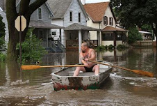
Click the photo to read about recent flooding on the Mississippi River.
Learn about hypoxia and the Gulf of Mexico dead zone.
Learn about nutrient pollution.

Why are snags important for a healthy river?

Learn about Nitrogen pollution in the Mississippi River basin.
Learn about the Nitrogen Cycle.

Learn more about Feathercraft.
Click on the colorimeter to learn more at wikipedia.com

Click the photo below to read Mississippi River Corridor's coverage of the Soggy Science Expedition
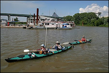
The Soggy Science team approaches the Memphis Yacht Club
Click the link below to visit the Mississippi River Corridor.

Click on the link below to visit the Tennessee Water Sentinels.

Click on the link below to visit the Sierra Club's Memphis area group.

About Me

- Aaron Reedy
- For the past seven years, I was a high school biology teacher at a public high school in Chicago. I am now pursuing the idea of being a teacher scientist in another arena as I pursue a PhD in evolutionary ecology at the University of Virginia. I recently gave a TED talk at TED 2012 http://blog.ted.com/2012/03/02/how-we-know-about-evolution-aaron-reedy-at-ted2012/
9 comments:
jaja Mr.Reedy
=) am i number one student comment? jaja
awesome!!
your going canoeing!
thats awesome!
jaja hope you post lots of pictures of what you see =D
i wAnt to see them :)
well have fun doing this during the summer :)
-Jesus Anaya
Glad to see that my students are paying attention! I will definately be putting up pictures on the blog. Jesus,(or any students or interested folks out there)send me your email and I will put you on the list to get an email notice whenever I post new material or photos. Thanks for posting!
Mr. Reedy
Dear Mr. Reedy,
I am looking forward to starting the trip! The news today seemed to reveal some facinating challenges ahead for us. It seems the flood levels are the highest they have been in 15 years!
Patrick
UPDATED: 03:41 AM EDT June 11, 2008
DES MOINES, Iowa (AP)
Rising rivers wiped out an Iowa railroad bridge Tuesday, flooded Illinois farmland and forced residents along the Mississippi River to prepare for what could be the worst flooding in 15 years.
In Cedar Falls, Iowa, officials were readying residents and downtown business owners to evacuate as the Cedar River threatened to spill over a levee. The river was expected to top the levee early Wednesday, prompting a mandatory evacuation of downtown, Mayor Jon Crews said.
"I've been downtown for 37 years and I have never seen anything like this," said Steve Schomaker, a partner in a local insurance company.
In nearby Waterloo, fast-moving water swept away a railroad bridge used to transport tractors from a John Deere factory to Cedar Rapids. It also prompted the city to shut its downtown and close five bridges.
Levee breaks Tuesday in southeastern Illinois flooded 50 to 75 square miles of farmland along the Embarras River, forcing the evacuations of homes northeast of Lawrenceville, said Lawrence County Sheriff Russell Adams. He said water was up to the roofs of some rural homes.
In Elnora, Indiana, about 100 miles southwest of Indianapolis, berms of white sandbags and concrete barriers held back the White River, leaving residents little choice but to wait and watch. Most residents left after voluntary evacuation orders came late Monday, two days after the area got up to 10 inches of rain.
"We have a very touch-and-go situation there, but everything that can be done has been done," Indiana Gov. Mitch Daniels said.
Along the Mississippi River, the National Weather Service on Tuesday predicted crests of 10 feet above flood stage and higher over the next two weeks. Most of the towns are protected by levees, but outlying areas could be flooded.
"This is major flooding," weather service hydrologist Karl Sieczynski said of the Mississippi. He urged people in unprotected flood plain areas to seek higher ground.
Canton, Missouri, about 150 miles north of St. Louis, could get the worst of the Mississippi River's flooding. The town of 2,500 is expected to see a crest on June 18 that is nearly 12 feet above flood stage.
Mayor Joe Clark said the levee is high enough to protect the community, but a sandbagging operation is planned to make sure it holds.
"I would say we're taking it in stride at this point," Clark said. "We live with this all the time."
Downtown Hannibal, Missouri, which includes Mark Twain's boyhood home, is protected by a flood levee that was completed just months before devastating floods in 1993. Still, a few homes would be flooded if the crest prediction is accurate.
In Wisconsin on Tuesday, engineers and contractors began repairing damage done when 267-acre Lake Delton overflowed and drained, washing away three houses. The rushing water had ripped apart underground sewer lines, and on Tuesday morning raw sewage was pouring out of the pipes and running down the Wisconsin River.
A dozen workers stretched a temporary sewer line across the 200-yard breach.
Gov. Jim Doyle said he would seek a federal disaster declaration.
Wisconsin officials also decided to close the westbound lanes of Interstate 94 because water from the rising Rock River was inches away from the road.
In Michigan, utility companies said it would take several days to fully restore service to nearly 180,000 homes and businesses without power after several days of severe storms.
In Minnesota, Gov. Tim Pawlenty signed an executive order declaring a state of emergency in two counties hit by flooding in the state's southeast corner.
...(continued with unrelated story)
cool!
:D
it looks like you guys are going to have an adventure with that nasty weather =/
hope you guys are ok...
:)
hopefully the trip goes well...
and hopefully you guys take awsome pictures :D
Hi Aaron,
We are so excited to follow along with your adventure! You will have so much to share with your students. Thanks for the Fund For Teachers endorsement!
Sarah Rossi
Chicago Fdn for Education & Fund For Teachers
hey mr reedy its juan everything hers good i got 2 bunnies from my aunt on Thursday now i have 4 1 day old baby bunnies hows ur trip going u didnt tell me i had 2 make 1
Hey mr. reedy is the weather treating you guys right? :D
hope everyhting is okay!
.....:)
the pictures look awsome!
Post a Comment