2010/04/21
Soggy Science @ TEDxSMU
Thanks again to the amazing team at TEDxSMU for giving me the chance to bring the Soggy Science expedition and my view on the changing role of the teacher to a wider audience. If you like the talk, please forward the link (http://www.tedxsmu.org/talks/) to anyone who is interested in education or to other teachers that you think could benefit from a Fund for Teachers fellowship. Click the TEDxSMU link to the right to watch the talk.
2009/12/04
TEDxSMU

I recently had the opportunity to speak about the Soggy Science Expedition and its impact in my classroom at the TEDxSMU conference in Dallas, TX at Southern Methodist University. The TEDx events are independently organized TED events that are attempting to make the TED experience accessible to more people around the world. If you are not familiar with TED, it stands for Technology Entertainment and Design. For more than 20 years, the TED conference has sought to spread great ideas from leading thinkers among invitation only audiences of the most innovative thinkers around. Past TED speakers have included Al Gore, Jane Goodall, Bill Clinton, Stephan Hawking, Bill Gates and many others. If you have not seen the TED website, they have hundreds of the talks available free online and I highly recommend viewing them at TED.com.
Initially, when I was asked to speak at TEDxSMU, I was thrilled. However, as I considered the acts that I was going to follow, (world famous undersea explorer Dave Gallo, brilliant mathemagician Art Benjamin, nationally renound physicist Amory Lovins and inspirational inventor William Kwamkamba to name a few) I became terrified. How would I be able to take the same stage as so many who are so well respected in their respective fields? When it came time to take the stage I was extremely nervous, but I went out and shared my Soggy Science experience and tried to convey the enthusiasm that I had for the project. The audience was extremely supportive and I feel like my talk was well recieved. Thank you so much to all of you who found me at the afterparty to let me know that you enjoyed the talk. Thank you TEDxSMU for giving me the chance to share my story.
My talk will be available online within the next few months at www.ted.com
2008/07/25
The analysis phase is just beginning.

I have been back in Chicago for a week now. I want to extend a special thank you to all of the people who extended their kindness to our team along the way. Your help was appreciated more than you can know.
If you have been following the blog you will notice that some rearranging has been done. All of the posts from the river are now in chronological order. If you are looking for the most recent posts, scroll down towards the bottom of the page.
If you would like to see more pictures from the river, check out the link to the right for a photo slide show of the expedition.
If you have a question or just want to say hi, please leave a comment on the blog.
Day 1: St. Louis, Missouri
Today we will be heading to
Update
 Day 1: Slow Start
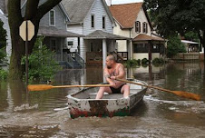
We found the perfect put in point. In St. Louis on the river bank 300 feet north of the Arch, there are a set of sandstone stairs that lead down the grassy river bank to the road running along the river. The major flood conditions of the swollen river had brought the waters up to a level where they were completely covering the road and were lapping at the base of the wide lower stairs. The thick stone railing of the staircase curved at its lower section and provided a pocket of sheltered water to enter the river. Street signs standing in the water framed our route like colorful channel markers. In the background the Arch stood proudly gleaming. This was a spot worthy of embarking on a great adventure.
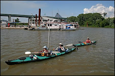
Despite standing at the perfect put in point with our gear at the ready, as we looked out at the river we briefly reconsidered our intentions to put in at St. Louis. The mid channel current of the river was whipping by at around 8 miles per hour. That kind of velocity in itself is not alarming but as you watch dozens of full sized cottonwood tree more than 40 feet in length and 2 feet in diameter, some complete with massive roots attached, being hurled along at that speed and occasionally twirled like bathtub toys by small eddies, it makes you consider the insignificant size and weight of a kayak. Patrick, Sarah and I all have experience kayaking in the ocean, on the Great Lakes and on different rivers and are all confident paddlers. Staring at the spectacle of the Lower Mississippi in the midst of a historic flood stage was humbling to say the least. For the sake of my parents and Patrick’s wife Molly, who stood looking on and who all had graciously volunteered to deliver our team and our gear to St. Louis, we tried to down play any doubts that we were having as we decided that the flood conditions, although warranting serious caution, were within our combined ability levels and decided to stick to our decision to begin paddling in St. Louis.
We began assembling the kayaks and loading the food and gear. After nearly three hours of preparations on the sandstone steps under an increasingly hot sun. We were nearly reading to say our good byes and put our boats in the water. At that moment a man who worked for the National Park Service and carried a badge but no gun walked down the steps and delivered news we had been hoping not to hear. “You aren’t planning to launch those kayaks are you?” This was a ridiculous question given that we were loading two kayaks about 5 feet from the waters edge. We had no response. So he quickly followed his opening line with “The River is closed to all recreational vehicles as far South as the Jefferson Barracks Bridge.” We offered a few weak dejected looks of disappointment but the man made it clear that he would be watching us until we moved to haul the gear and the boats away from the river. We strapped the boats to the roof of my parents’ car and headed for the Plattin Rock Boat Club marked on the nautical charts as 33 miles South of St. Louis and just south of the Jefferson Barracks Bridge.
Day 2: Southern Hospitality, Crystal City, MO to Chester, IL (41 river miles)
When we arrived yesterday at the Plattin Rock Boat Club, we had no idea what to expect. What we found was a river spilling over its banks by nearly a quarter mile and a small town boat club deeply in love with the river and very supportive of our trip. After being kicked off of the steps of the Arch in St. Louis, we were a bit wary of asking permission to launch our boats. We timidly approached an older man named Lou who stood fishing on the grassy knoll that was being slowly swallowed up by the rising water of the river. He immediately told
 me that he thought we were crazy and that the river was much too dangerous for paddling at the moment; his biggest concern was that with the banks of the river nearly 6 to 10 feet underwater, we would only be able to stop for camp or even a brief rest at flooded boat ramps where we would find a break in the trees leading to the roads that serviced them.
In nearly the same breath that he called us crazy he also invited us to make camp near the train tracks behind the boat club and get a fresh start in the morning. We took him up on the offer and pitched our tent on the shallow rise below the tracks and hoped that the water would not rise the nearly 4 more feet that it was predicted to come up in the next 24 hours. We bid farewell to my parents who needed to head back to Chicago, and went about the task of organizing our gear for the next morning and conducting our first water tests.
For the next 4 hours there was a steady parade of people driving down to the river to see the biggest flood in fifteen years. Inevitably people would see our boats and ask about our trip. They nearly all called us crazy but they wished us a safe journey and asked if there was anything that they could do to help. One man who seemed genuinely worried for our safety presented us with a wood and silver crucifix that he said belonged to his mother. He told us to keep it with us during our journey. Patrick mounted the gift on his kayak and Jesus on the bow has been with us for every mile of the trip.
In the morning we broke camp and said our goodbyes to Molly and cautiously paddled down the flooded street out into the main channel. We found strong currents and pockets of swirling water but paddling it was manageable and within the first ten minutes Sarah, Patrick and I felt good about our decision to begin the trip in a flooded river. We made miles fast and around 5:00 pm we fought our way out of the current and pulled into the boat club at Chester, IL. This evening we had no visitors; all roads leading to the boat club had been flooded, completely cutting the clubhouse off from the rest of the town

Day 3: Chester, IL to Trail of Tears State Park, Missouri (47 river miles)
 We ran into a disconcerting patch of white water late in the afternoon but paddled through without incident. Trail of Tears State Park seemed eerily abandoned due to the surrounding flooding. Again another night of no human visitors. A raccoon did come by in the middle of the night to investigate our food bag. Patrick and I promptly ran the raccoon into a tree and proceeded to bombard the animal with projectiles. I think we really scared it because it urinated on Pat’s face as he was trying to film it.
Day 4: We still have a lot to learn. Trail of Tears State Park, Missouri to Scudder Light (51 river miles)
This ended up being our toughest day so far. Throughout the morning we made quick miles and were starting to feel like we knew what to expect. Around 5:00 pm we began to close in on Thompson boat ramp which was our chosen landing point for the night. As we approached our destination a commercial barge more than 300 feet in length started coming around the bend. We pulled closer to the outside edge to avoid the barge but as we moved over to the edge we moved into a thick belt of fast moving trees and debris.
We were concerned that the wake from the barge would toss us into waves carrying this debris but assumed that the Thompson boat ramp would come into view at any moment. The ramp never appeared and we hurriedly ducked in behind some trees to get cover from the waves and debris. Almost immediately we realized that this was a mistake. We were trapped behind a precarious log jam and a vicious swirling counter current that threatened to release the log jam and pummel our boats with heavy tree trunks. On land the river abruptly ran against a dense jungle like patch of forest infested with mosquitoes and lacking any space free of downed logs to pitch a tent.
We debated a solution to our situation and decided to make a break for it. We watched the three swirling holes that blocked our exit and followed the paths of logs heavier than our kayaks as they circled into the center of the holes and were briefly pulled under the water. We definitely wanted to avoid those spots. We planned to ride the counter current back up river for about 30 feet and then use the swirling edge of the pool to sling shot us back out closer to the main channel. With pulses pounding, the three of us in our two boats paddled as hard as we could into the current.
We successfully avoided the largest of the holes but paddled right into a smaller one that had remained hidden to us from the shore. We quickly rafted our kayaks together and floated over the hole with a good speed and plenty of steerage way moving over our rudders. For a brief moment I could begin to feel Patrick’s kayak get sucked down into the water. It was a huge relief as soon as I felt it come back up with two inches of freeboard to spare.
We now had only two hours of daylight remaining and more than 20 miles to the next boat ramp. After three miles we found a tiny sliver of sand on the opposite bank just behind a signal light. It wasn’t nearly big enough for two tents so while Sarah cooked dinner, Pat and I cleared a patch of beach with a machete. This proved to be a fool's chore as we developed horrible cases of poison ivy over the next 24 hours.

Day 5: The Ohio joins the Team. Scudder Light to Columbus, KY (34 river miles)
We cut it short today because of a brutal heat. The confluence of the Ohio and Mississippi Rivers proved to be a very easy patch of water. When stopped at Columbus we were adopted by a man named Tony and his family. They hung out with us for hours and brought us cold drinks.
Day 6: Columbus, KY to Linda Boat Ramp (61 river miles)
Very long day and we are extremely tired. We camped beside a soybean field and were treated
 to the kind of sunset that you don’t easily forget. Kind fishermen and fisherwomen gave us cold sodas and a pack of hot dogs.
Day 7: Linda Boat Ramp to Island #21 (46 river miles)
Island number 21 is the most beautiful spot in the world. We pitched our tent on a white sand beach that stretched for miles and although the shorebirds might disagree, it was our own private island.

Day 8: Island # 21 to Hatchie Towhead (52 river miles)
We stayed on the water all day today. The current is slowing down and our speed has been slower. We camped beside a newly planted field atop a steep eroding bank.
We stayed on the water all day today. The current is slowing down and our speed has been slower. We camped beside a newly planted field atop a steep eroding bank.

Day 9: Memphis Welcome! Hatchie Towhead to Memphis, TN (34 miles)
We arrived in Memphis and were greeted at the Memphis Yacht club by members of the Mississippi River Corridor and the Memphis chapter of the Sierra Club. They interviewed us and watched us do a round of water testing on the docks. We were pleasantly surprised to hear that they were interested in our trip and had been following our progress. They are posting information about our trip and our research. Look for links to these organizations on this blog in the future.
A short while later after tying the boats to the docks, we were picked up by a good friend’s mother who is quickly becoming a good friend herself. She has graciously taken us into her home. In Memphis we have restocked supplies, visited a doctor seeking treatment for multiple heat related skin conditions, and been treated to some of the best barbecue around. Rest day tomorrow.

High School Biology Teacher, Aaron Reedy
Post from Catfish Point
**PHOTO UPDATES**
 We started out making good paddle time but late in the afternoon, our progress slowed to a crawl when a stiff headwind reared up and formed steep waves against the current. By late in the afternoon, our progress was reduced to around three miles per hour. Just as we were ready to get off the river, we saw a castle to our left.


I'm dictating these posts via cell phone from my camp here on Catfish Point just off the Mississippi bank at Mile Marker 569. Unfortunately these posts will be text only and I will update these with photos when I am able to get to a computer.
Day 12:
 We started out making good paddle time but late in the afternoon, our progress slowed to a crawl when a stiff headwind reared up and formed steep waves against the current. By late in the afternoon, our progress was reduced to around three miles per hour. Just as we were ready to get off the river, we saw a castle to our left.
The green turrets and castle walls were part of the facade of the Fitz Hotel and Casino in Tunica,
Day 13:

Around
Bubba typifies the type of people we meet along the river - talkative, friendly, outgoing and willing to lend a helping hand if the need is there. As we parted ways, Bubba sent us off with a roll of fishing line and his best advice on how to catch a catfish. We paddled on toward 

Day 15:

This morning I woke with the sunrise and walked on the beach to check the fishing line that we had set out the night before. For the first time this trip, there was a catfish on the hook. Fried with some salt and pepper, it was an excellent addition to our cold breakfast.
After two hours of paddling, we reached a significant milestone on our trip, the halfway point.

Live from Vicksburg

These posts are being put up from the Vicksburg office of the Army Corps of Engineers. Thank you Mark Richter for all of your help!
Day 16: Kentucky Bend Bar to Arcadia Point, MS (50 river miles)
The morning was chaotic. By this point in the trip Sarah, Patrick and I have a routine down. Each camp item gets packed away in a specific spot in the boats. Each drybag has to go in the proper order or things will not fit. Some things remain in the boats at all times. On this morning our routine was broken because Patrick had to empty his entire boat the previous afternoon. At the end of the day he found that the hold of his boat had filled with about an inch of water. He emptied everything out to try to find the leak and make repairs. His boat is still leaking but it appears to be more of an annoyance than a serious safety issue. Even with a complete repacking we left the beach by 8:00. By 10:00 it seemed like the sun was set to broil. We applied 50 SPF sunscreen nearly every hour and still the backs of our hands and our forearms burned. Sarah's lips began to burn despite applying sunblock chapstick constantly. We dipped our shirts into the river to stay cool and the wet fabric dried in less than 30 minutes. Paddling in the heat was draining but we were pushing hard to make it to Vicksburg, MS by the 4th of July. Around 1:00 we paddled into a swampy inlet to eat lunch and escape the sun. The only shade was among the mud behind the trees. We found a few logs to sit on to keep us from sinking completely into the deep mud. We have eaten lunches in a lot of beautiful settings on this trip but this mud pit was not one of them. All around us there were animal tracks. We have seen so many animal tracks in the mud that we almost stopped taking notice but now we have been noticing a new kind of track...alligator! Alligator tracks have a way of making you take notice. We kept our eyes open for gators as we ate our beans and rice but all we saw was a crawfish scuttling through the muck.
After lunch we returned to the sun. It only got hotter as the light breeze completely died. I found myself looking at my watch every ten minutes, hoping the day was closer to sun down and then being disappointed to find that it was only ten minutes closer. This heat was made worse by the fact that we were running low on water. I had finished the two liters that I had on deck long ago and was starting to think about the unpleasant realization that we were going to need to ration our water to make it to Vicksburg by the end of the day tomorrow. Around 5:00 our team morale was low and we were all looking forward to getting off of the water. We spotted a private boat ramp on the nautical chart and chose it as our ending point for the day on the chance that it may have a drinking water source. Many of the private boat ramps on the charts have been in the midst of vacation cabins and have had water available. The charts have proved to be very accurate. The only time they have been inaccurate so far we ended up in a tight spot hunting for the non-existent Thompson boat ramp in Missouri. This was the second time that the charts have been less than accurate. There was no ramp. We did spot a house and pulled onto a sandy bank to investigate.
The house proved to be in a state of abandonment. The grass was overgrown and buzzing with mosquitoes. There was a water tank atop a crooked wooden tower. PVC pipes led down from the tank to a tap. When I turned the rusty spigot we were disappointed to receive about a cup full of brown murky liquid. This was not the campsite we were hoping for. Even though we were dreading it, we returned to the kayaks and paddled on with less than an hour of daylight remaining.
We paddled two more miles around a bend and were disappointed to see miles of dense forest lining both sides of the channel. We were very close to facing a night with very little water on a steep slope with no space for tents. We all paddled in silence. Then we saw something in the distance.
A few miles up we spotted a clearing. In the clearing stood a large house. New hope for a campsite returned to our kayaks. It turned out to be better than we could have hoped for. As we got closer, a man ran out to the water’s edge and waved us in. Almost as soon as we stepped on to land, Glen, Althea, Bobby and June were insisting that we come inside the large house get cleaned up. We spent the evening talking, eating and drinking with our new friends. Once again we were shown the meaning of Southern hospitality.

Day 17 We made it to Vicksburg, MS! Happy 4th of July! (33 river miles) 
Only 337 miles to New Orleans! Look for a big post with lots of pictures when we get there!
Subscribe to:
Posts (Atom)